News
Show me:
Huge Apple CarPlay update revealed: Siri AI, improved maps, audio player and more
Huge Apple CarPlay update revealed: Siri AI, improved maps, audio player and more
The latest rendition of Apple CarPlay comes courtesy of iOS27 which will be made fully available to the public later this year
New Fiat 600 manual undercuts its EV counterpart by £3,000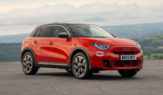
New Fiat 600 manual undercuts its EV counterpart by £3,000
This latest version of the Fiat 600 gets a six-speed manual and a petrol engine capable of around 50mpg
New Fiat 500 Hybrid's tiny price makes it one of UK's cheapest cars
New Fiat 500 Hybrid's tiny price makes it one of UK's cheapest cars
Prices for the new petrol-powered Fiat 500 have been revealed, with UK cars due this summer
Car Deal of the Day: Cupra Formentor prices keep on falling – it’s now just £203 a month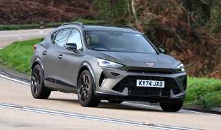
Car Deal of the Day: Cupra Formentor prices keep on falling – it’s now just £203 a month
The Cupra Formentor is a sporty coupé-SUV on a shoestring. It’s our Deal of the Day for 8 June.
The shift to EV is my biggest fear, says Toyota boss Akio Toyoda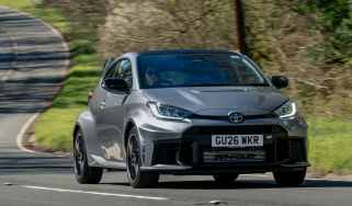
The shift to EV is my biggest fear, says Toyota boss Akio Toyoda
A ‘good balance sheet’ and ‘carbon neutral cars’ are not what excites the Toyota boss
New Peugeot 208 GTi: first images of production car revealed
New Peugeot 208 GTi: first images of production car revealed
Exactly a year after the concept was shown at Le Mans, Peugeot has finally unveiled its new-age hot hatchback
Radical new Citroen C4 Picasso successor will be boxy, practical and futuristic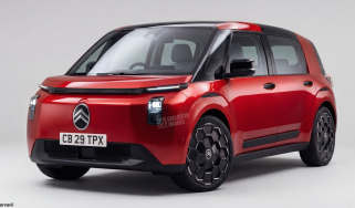
Radical new Citroen C4 Picasso successor will be boxy, practical and futuristic
Citroen is going back to what it does best: new MPV will be boxy, practical and family-friendly
New Vauxhall Astra confirmed for 2030 but big change is on the cards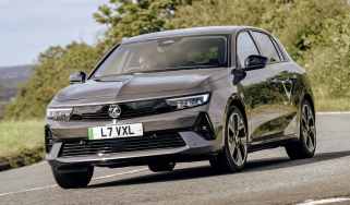
New Vauxhall Astra confirmed for 2030 but big change is on the cards
Famous badge has been around since 1980, but while the next Astra is guaranteed to offer an estate body and electric power, a hatchback is not certain
Electric car prices set to rise if Brexit deal isn't amended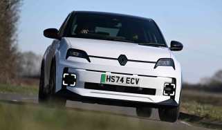
Electric car prices set to rise if Brexit deal isn't amended
The EU-UK Trade and Cooperation Agreement requires a significant proportion of a vehicle is made in Europe if it wishes to avoid hefty tariffs
Car Deal of the Day: hello £290 a month Nissan Leaf, goodbye range anxiety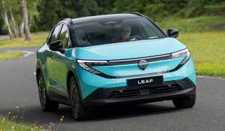
Car Deal of the Day: hello £290 a month Nissan Leaf, goodbye range anxiety
Our Deal of the Day for 7 June is the new, super-sleek evolution of Nissan’s electric family hatchback
New Ford Fiesta ST confirmed as fast Fords are ‘non-negotiable’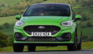
New Ford Fiesta ST confirmed as fast Fords are ‘non-negotiable’
Fast Ford fans rejoice, as the top-brass confirm that ST and maybe even RS models are firmly part of the plan
Forget Bugatti, Chery's Tiggo 4 is a car I didn't want to give back
Forget Bugatti, Chery's Tiggo 4 is a car I didn't want to give back
Forget Bugatti, Mike Rutherford is seriously impressed with Chery's Tiggo 4
Car deal of the day: Vauxhall Corsa for £168 per month is almost too cheap to be true
Car deal of the day: Vauxhall Corsa for £168 per month is almost too cheap to be true
The Vauxhall Corsa is a stylish supermini with plenty of standard equipment. It’s our Deal of the Day for 6 June.
I went to China and was left stunned by all the car brands that could still hit the UK
I went to China and was left stunned by all the car brands that could still hit the UK
Senior content editor Shane Wilkinson explains why getting to grips with China’s car brands is an exceptionally daunting task
Lotus Esprit comeback in new detail: all-wheel drive and 1,000bhp hybrid power for Type-135 supercar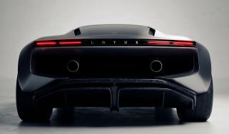
Lotus Esprit comeback in new detail: all-wheel drive and 1,000bhp hybrid power for Type-135 supercar
Lightweight chassis with advanced adaptive control systems should make for a thrilling drive, CEO Qingfeng Feng exclusively reveals
Car Deal of the Day: a touch of luxury with the Lexus RX for £477 a month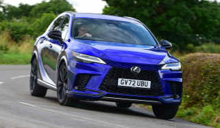
Car Deal of the Day: a touch of luxury with the Lexus RX for £477 a month
The RX is Lexus’s halo SUV, but you wouldn’t think so at this price. It’s our Deal of the Day for 5 June.
New Hyundai i20 spied with a dramatic Ioniq 3 inspired look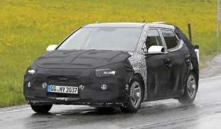
New Hyundai i20 spied with a dramatic Ioniq 3 inspired look
New design, new technology and hybrid powertrains could put Korean contender right at the sharp end of the supermini class
The Lotus CEO first saw an Esprit in a movie – but you’ll never guess which one…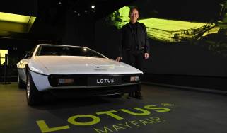
The Lotus CEO first saw an Esprit in a movie – but you’ll never guess which one…
Qingfeng Feng was a student when a movie introduced him to the Lotus brand. Now he’s bringing the Esprit back as a V8 hybrid
Blanket 20mph speed limits proposed, because we can’t afford the signs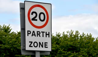
Blanket 20mph speed limits proposed, because we can’t afford the signs
The Parliamentary Advisory Council for Transport Safety is pushing for reduced speed limits to save lives… and public money
Nissan’s plan to build Chery’s Chinese cars in Sunderland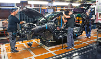
Nissan’s plan to build Chery’s Chinese cars in Sunderland
Nissan could start building Chery and potentially even Jaecoo and Omoda cars from 2027
Shock new Audi Nuvolari supercar arrives: 986bhp R8 successor costs £500k
Shock new Audi Nuvolari supercar arrives: 986bhp R8 successor costs £500k
Audi’s half-million-pound supercar is ready to rock the automotive establishment
New Audi Q4 e-tron: the cheapest Audi EV just got even cheaper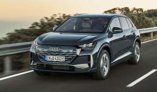
New Audi Q4 e-tron: the cheapest Audi EV just got even cheaper
Audi’s second best-selling car has just been made even better
Car Deal of the Day: Volvo EX30 offers Swedish cool for a hot £262 a month
Car Deal of the Day: Volvo EX30 offers Swedish cool for a hot £262 a month
Few small electric SUVs are as cool-looking as the Volvo EX30. It’s our Deal of the Day for 4 June.
China's XPeng enforces special driving test for users of autonomous cars
China's XPeng enforces special driving test for users of autonomous cars
XPeng CEO says he wants customers to ‘pass a test’ before being given access to autonomous-drive features
BYD is a Chinese car brand, but it wants to be European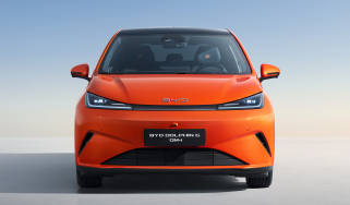
BYD is a Chinese car brand, but it wants to be European
It turns out that European and Chinese drivers expect many different things from their cars, so BYD is taking drastic action
VW electric cars will soon be as cheap to build as its petrol ones
VW electric cars will soon be as cheap to build as its petrol ones
VW Group CEO Oliver Blume reveals cost-cutting solutions for delayed SSP platform
China beats Japan and Korea: Chinese cars now more popular with UK buyers
China beats Japan and Korea: Chinese cars now more popular with UK buyers
As many as 138,856 Chinese cars have been registered in the UK since the start of 2026
New Lamborghini Lanzador 'ultra-GT' to fill the gap between supercars and the Urus SUV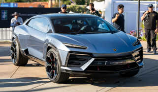
New Lamborghini Lanzador 'ultra-GT' to fill the gap between supercars and the Urus SUV
The Lanzador was due to be Lamborghini’s first EV and have about 2,000bhp, but now it’s getting plug-in hybrid power
Don’t ignore Saab and Rover! Dead brands now make for serious used car bargains
Don’t ignore Saab and Rover! Dead brands now make for serious used car bargains
Auto Express’s senior news reporter explains why you shouldn’t dismiss a car from one of the many brands now defunct in the UK market
New Skoda Peaq seven-seater revealed in sketches ahead of 23 June launch 
New Skoda Peaq seven-seater revealed in sketches ahead of 23 June launch
Skoda’s ‘Modern Solid’ design language takes a big step forward with its largest EV yet
Ford Focus primed for sensational return, but as an SUV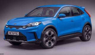
Ford Focus primed for sensational return, but as an SUV
Could a new Ford Focus be ready to fight Europe’s biggest sellers such as the Volkswagen T-Roc and Nissan Qashqai?
Car Deal of the Day: Skoda Kodiaq is a ‘Simply Clever’ choice at £233 a month
Car Deal of the Day: Skoda Kodiaq is a ‘Simply Clever’ choice at £233 a month
Families love the Skoda Kodiaq – and at this price it’s easy to see why. It’s our Deal of the Day for 3 June.
New Ford Bronco set for 2028, and it’s coming to the UK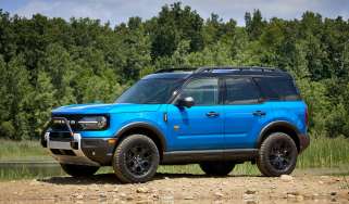
New Ford Bronco set for 2028, and it’s coming to the UK
A new and far more rugged off-roader is on its way to toughen Ford’s future model line up
New Fiat Grizzly: fresh info on Grande Panda’s bigger brother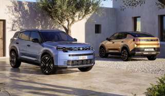
New Fiat Grizzly: fresh info on Grande Panda’s bigger brother
Fiat says the Grizzly SUV will offer “best in class” boot space when it arrives later in 2026
New Rolls-Royce Black Badge Ghost Tourist Trophy is as sporty as a Roller can be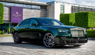
New Rolls-Royce Black Badge Ghost Tourist Trophy is as sporty as a Roller can be
Rolls-Royce celebrates 120 years since Henry Rolls’ Isle of Man win with one-off Ghost.